
 By Global Arena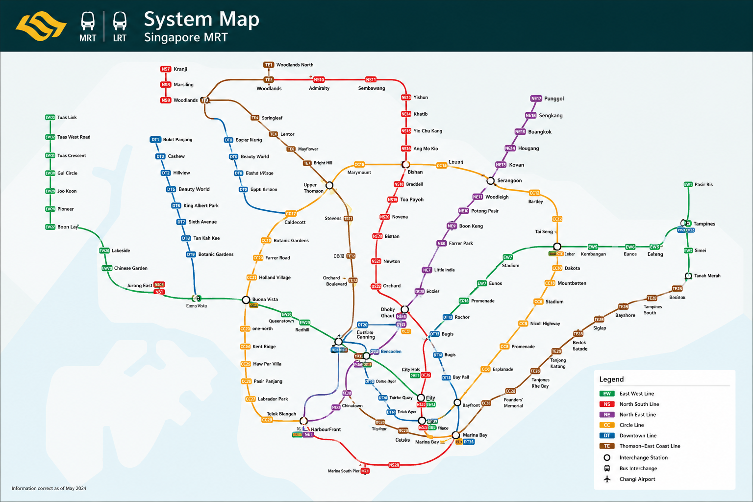
Singapore’s MRT map shows the city’s train lines, stations, and interchange points in one easy view. Different colours represent each MRT line, helping passengers quickly find routes and where to change trains.
For tourists, it makes trips to places such as Changi Airport, Marina Bay, Orchard Road, and Chinatown easier to plan. Daily commuters can also use it to find quicker connections across Singapore. With the MRT network continuing to grow, checking the updated 2026 map can help you plan your journey before travelling.
Singapore MRT Map at a Glance
The Singapore MRT system connects residential areas, business districts, shopping streets, and major attractions across the island. The network has six main MRT lines: North-South, East-West, North East, Circle, Downtown, and Thomson-East Coast.
MRT trains cover longer routes and connect major parts of Singapore. The LRT serves shorter local routes, mainly linking neighbourhoods with nearby MRT stations.
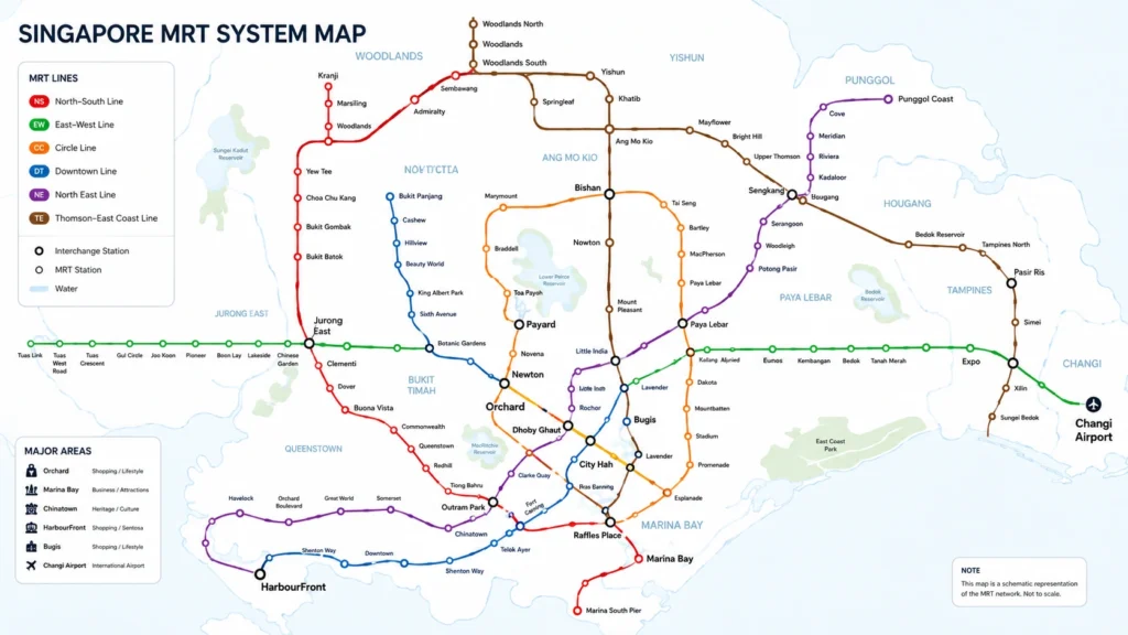
Reading the Singapore MRT map is fairly simple. Every line has a separate colour, so passengers can follow their route visually. Stations also have codes such as NS, EW, NE, CC, DT, and TE, followed by a number. For example, Orchard is NS22 on the North-South Line and TE14 on the Thomson-East Coast Line.
Interchange stations display codes for more than one line. This makes it easier to see where you can switch trains during a journey.
Singapore MRT Lines and Their Colours
Singapore’s six MRT lines are identified by different colours on the map. Knowing these colours can make route planning much quicker, especially for first-time visitors.
| MRT Line | Colour | Main Areas | Useful Stations |
| North-South Line | Red | North, Orchard, City | Orchard, City Hall |
| East-West Line | Green | West, CBD, East | Bugis, Tanah Merah |
| North East Line | Purple | North-East, Central | Chinatown, HarbourFront |
| Circle Line | Yellow | Central & South | Bishan, Marina Bay |
| Downtown Line | Blue | Downtown, East | Bugis, Little India |
| Thomson-East Coast Line | Brown | North, Central, East | Woodlands, Orchard |
The red North-South Line runs from northern Singapore through Orchard and the city centre. The green East-West Line is useful for travelling between western Singapore, the CBD, and eastern areas, with Tanah Merah providing an important connection towards Changi Airport.
The purple North East Line serves areas such as Chinatown and HarbourFront, while the yellow Circle Line provides useful connections around central Singapore without always requiring travel through the city centre.
The blue Downtown Line connects several residential areas with Little India, Bugis, and the downtown district. The newer brown Thomson-East Coast Line links Woodlands with central and eastern parts of Singapore, including Orchard and stations serving the Marina Bay area.
Instead of remembering every station, travellers can first identify the line colour and then follow the station codes to their destination.
How to Read the Singapore MRT Map
The Singapore MRT map may look busy at first, but it becomes easy to follow once you know the basic signs.
Line colours help you identify each MRT route. For example, red represents the North-South Line, while green represents the East-West Line. Every station also has a station code, such as NS22 for Orchard, which tells you the line and station number.
Interchange stations are places where two or more MRT lines meet. They are clearly marked on the map and let you change lines without leaving the rail network.
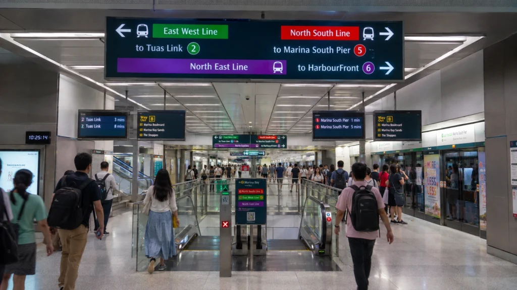
Before boarding, check the train direction. MRT platforms usually show the terminal station in each direction, so knowing the end or terminal station helps you choose the correct platform.
MRT and LRT services also use different line names, codes, and map markings. MRT covers longer journeys across Singapore, while LRT mainly serves shorter neighbourhood connections.
After reaching your station, check the exit signs carefully. Larger stations may have several exits marked A, B, C, or other letters. Choosing the correct exit can save walking time and bring you closer to your hotel, attraction, shopping centre, or final destination.
Major Singapore MRT Interchange Stations
- Dhoby Ghaut: Connects North-South, North East and Circle lines. Useful for Orchard, Little India and central Singapore.
- City Hall: Links North-South and East-West lines. Good for City Hall, Bugis and Marina Bay areas.
- Raffles Place: Connects North-South and East-West lines. Best for the CBD and financial district.
- Bugis: Links East-West and Downtown lines. Useful for Bugis, Little India and downtown trips.
- Outram Park: Connects East-West, North East and Thomson-East Coast lines. Handy for Chinatown and HarbourFront.
- Bishan: Links North-South and Circle lines. Useful when travelling between northern and central Singapore.
Singapore MRT Map for Tourists
Singapore’s MRT gives tourists an easy way to reach most major attractions. For Orchard Road, Orchard MRT (NS22/TE14) is a convenient choice, while Somerset also serves the shopping district. Visitors heading to Marina Bay Sands can use Bayfront MRT (CE1/DT16). Gardens by the Bay has its own station, Gardens by the Bay (TE22), on the Thomson-East Coast Line.
For cultural areas, Chinatown MRT (NE4/DT19) puts you close to Chinatown’s food streets, shops and heritage sites. Little India MRT (NE7/DT12) is the main stop for exploring Little India. To visit Sentosa, take the MRT to HarbourFront (NE1/CC29) and continue by Sentosa Express, bus, cable car or on foot.
Bugis MRT (EW12/DT14) is convenient for Bugis Street, shopping malls and nearby Kampong Glam. For the Singapore Flyer, Promenade MRT (CC4/DT15) is a useful stop and also provides access to other attractions around Marina Bay.
Singapore MRT Map to Changi Airport
Changi Airport is connected to the MRT network through Changi Airport MRT Station (CG2), located between Terminals 2 and 3. It is a convenient option for travelling between the airport and central Singapore.
For most journeys, passengers change at Tanah Merah MRT (EW4/CG) and continue on the East-West Line towards the city.
- Airport to City: Changi Airport → Tanah Merah → East-West Line → City
- City to Airport: East-West Line → Tanah Merah → Changi Airport
- Popular connections: Bugis, City Hall and Raffles Place can be reached through the East-West Line.
Before starting your airport journey, check your terminal, MRT route, interchange station and travel time. If your trip is early in the morning or late at night, check the latest first and last train timings as well. Leave some extra time for transfers and walking between the MRT station and your airport terminal.
Best MRT Stations for Popular Singapore Attractions
Singapore’s MRT network covers most major tourist areas, making sightseeing easy without relying on taxis. The table below shows the nearest or most useful MRT stations for popular attractions.
| Attraction | MRT Station | Line | Area |
| Orchard Road | Orchard | NSL / TEL | Orchard |
| Marina Bay Sands | Bayfront | CCL / DTL | Marina Bay |
| Gardens by the Bay | Gardens by the Bay | TEL | Marina Bay |
| Chinatown | Chinatown | NEL / DTL | Chinatown |
| Little India | Little India | NEL / DTL | Little India |
| Sentosa | HarbourFront | NEL / CCL | HarbourFront |
| Singapore Flyer | Promenade | CCL / DTL | Marina Bay |
For shopping, Orchard MRT puts visitors close to the main Orchard Road malls. Bayfront is the preferred stop for Marina Bay Sands, while Gardens by the Bay MRT provides direct access to the gardens area.
Chinatown and Little India both have interchange stations, which makes them easy to reach from different parts of Singapore. For Sentosa, travel to HarbourFront and continue by Sentosa Express, bus, cable car or on foot. Visitors heading to the Singapore Flyer can use Promenade MRT.
Always check the station exit before leaving the MRT. Choosing the right exit can reduce walking time, particularly around larger stations and busy tourist areas.
Singapore MRT Map 2026 Updates
The Singapore MRT map was updated in 2026 with the opening of Circle Line Stage 6 (CCL6). It adds three stations — Keppel, Cantonment, and Prince Edward Road — linking HarbourFront to Marina Bay.
The Circle Line is now a full loop, improving travel around central Singapore. Keppel serves HarbourFront area, Cantonment is near Tanjong Pagar, and Prince Edward Road is close to the CBD.
This makes some cross-city trips easier and reduces transfers. Use an updated 2026 MRT map, as older ones may not show the new stations or full loop.
Singapore MRT Travel Tips for First-Time Visitors
Using Singapore’s MRT is simple, even if it is your first visit. A little planning before each trip can make travelling around the city much easier.
- Check your station first: Find the nearest MRT station to your destination before leaving.
- Follow the line colour: Use the colour shown on the MRT map to stay on the correct route.
- Watch interchange signs: At interchange stations, follow signs for the line you need next.
- Check train direction: Look at the terminal station shown on the platform before boarding.
- Find the right exit: Check the exit letter or number for your attraction, hotel, or street.
- Allow extra time during peak hours: Trains and major stations can be busier during morning and evening commuting periods.
- Check airport services: When travelling to Changi Airport, confirm the route, transfer point, and current train service information.
- Save a digital MRT map: Keeping the latest Singapore MRT map on your phone is useful when planning routes on the go.
These simple habits can help first-time visitors avoid wrong trains, unnecessary transfers, and extra walking.
Singapore MRT Map vs Google Maps and Journey Planners
A Singapore MRT map is best for seeing the full rail network, line colours, stations, and interchange points. It helps you understand how different MRT lines connect before planning a trip.
For an exact journey, Google Maps or a journey planner can be more useful. Enter your starting point and destination to see:
- Recommended MRT route and transfers
- Estimated travel and walking time
- Nearby stations and station exits
- Fare and transport information
For current public transport information, travellers can also check official LTA and MyTransport.SG resources. These are useful for train service updates, planned works, and disruptions that may affect your journey.
A good approach is to use the MRT map to understand the network, then check a journey planner for the exact route and timing. If there is a service change, check official transport information before travelling.
FAQs About Singapore MRT Map
How many MRT lines are there in Singapore?
Singapore has six main MRT lines: North-South, East-West, North East, Circle, Downtown, and Thomson-East Coast.
Which MRT line goes to Changi Airport?
Changi Airport MRT (CG2) is connected to the East-West Line via Tanah Merah MRT.
What is the best MRT station for Orchard Road?
Orchard MRT (NS22/TE14) is one of the best stations for reaching the main Orchard Road shopping area.
Which MRT station is closest to Sentosa?
HarbourFront MRT (NE1/CC29) is the main MRT station for Sentosa connections, including the Sentosa Express.
What are the main MRT interchange stations in Singapore?
Major interchanges include Dhoby Ghaut, City Hall, Raffles Place, Bugis, Outram Park, Bishan, Paya Lebar, HarbourFront, and Marina Bay.
What changed on the Singapore MRT Map in 2026?
Circle Line Stage 6 opened in 2026, adding Keppel, Cantonment, and Prince Edward Road stations and completing the Circle Line loop.