
 By Global Arena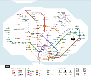
Singapore’s MRT system is one of the easiest ways to travel around the island. Whether you’re a daily commuter, a first-time visitor, or someone planning a trip around Singapore, understanding the MRT Line Map Singapore can save time, money, and plenty of confusion.
At first glance, the map might look complicated. Different coloured lines, interchange stations, and dozens of stops can feel overwhelming. But once you understand how the network works, moving around Singapore becomes surprisingly simple.
The MRT connects residential neighbourhoods, business districts, shopping areas, tourist attractions, and even Changi Airport. It’s fast, affordable, clean, and reliable — which is why millions of passengers use it every day.
This guide breaks down Singapore’s MRT network, explains the different lines, highlights important interchanges, and shares practical tips to help you travel like a local.
1. Understanding the MRT Line Map Singapore
The MRT Line Map Singapore is a visual guide showing all train routes across the island. Each MRT line has its own colour, name, and purpose.
Currently, Singapore’s MRT network includes several major lines:
- North-South Line (NSL) – Red Line
- East-West Line (EWL) – Green Line
- North East Line (NEL) – Purple Line
- Circle Line (CCL) – Yellow Line
- Downtown Line (DTL) – Blue Line
- Thomson-East Coast Line (TEL) – Brown Line
There are also future extensions planned to improve connectivity between different parts of Singapore.
The easiest way to read the map is by focusing on three things:
- The line colour
- The station name
- Interchange points where lines connect
You don’t need to memorise every station. Honestly, even many locals don’t. They simply check the route before travelling.
2. North-South Line (Red Line): Connecting Northern Singapore to the City
The North-South Line was Singapore’s first MRT line and remains one of the busiest routes today.
It runs from Jurong East in the west to Marina South Pier in the south, connecting many residential areas with the city centre.
Popular stations along this line include:
- Jurong East
- Woodlands
- Bishan
- Orchard
- Dhoby Ghaut
- City Hall
- Marina Bay
This line is especially useful for commuters travelling from northern towns such as Woodlands, Yishun, and Ang Mo Kio into central Singapore.
For tourists, stations like Orchard and Marina Bay provide easy access to shopping streets, hotels, attractions, and business areas.
The North-South Line is shown in red on the MRT Line Map Singapore, making it easy to identify.
3. East-West Line (Green Line): The Longest MRT Route
The East-West Line is another major route connecting eastern and western Singapore.
It stretches from Pasir Ris to Tuas Link, with a branch serving Changi Airport.
Important stations include:
- Tampines
- Paya Lebar
- Bugis
- City Hall
- Raffles Place
- Jurong East
- Tuas Link
This line is extremely important because it connects Singapore’s main business districts with residential areas.
Travellers arriving at Singapore Changi Airport can also use the East-West Line extension. The airport MRT station connects passengers directly to the wider train network.
For visitors staying near Orchard, Bugis, or Marina Bay, the green line is often part of their journey.
4. North East Line (Purple Line): Linking HarbourFront and Punggol
The North East Line connects Singapore’s northeastern neighbourhoods with HarbourFront in the south.
Major stations include:
- Punggol
- Sengkang
- Serangoon
- Little India
- Chinatown
- HarbourFront
This MRT line is popular among residents living in areas like Punggol and Sengkang.
It is also convenient for tourists because it reaches several attractions:
- Chinatown
- Little India
- VivoCity shopping mall
- Sentosa Island connections
The purple line is fully underground, offering comfortable travel regardless of Singapore’s weather.
5. Circle Line (Yellow Line): The City Connector
The Circle Line changed how people travel around Singapore. Instead of always travelling through the city centre, passengers can now move between different areas more directly.
The yellow line forms a loop around central Singapore.
Key stations include:
- Dhoby Ghaut
- Bras Basah
- Promenade
- HarbourFront
- Bishan
- Serangoon
This line is especially useful for reaching:
- Museums
- Sports venues
- Shopping areas
- Entertainment districts
For example, visitors heading to Marina Bay Sands, Gardens by the Bay, or the Singapore Sports Hub often use Circle Line connections.
The Circle Line is one of the most useful routes to understand when reading the MRT Line Map Singapore.
6. Downtown Line (Blue Line): A Route Through Singapore’s Modern Districts
The Downtown Line connects the northwestern areas of Singapore with the central business district.
Important stops include:
- Bukit Panjang
- Botanic Gardens
- Little India
- Bugis
- Downtown
- Chinatown
This line provides convenient access to areas that previously required multiple transfers.
The Downtown Line is especially popular with students, office workers, and visitors exploring Singapore’s heritage and business districts.
Stations like Bugis and Chinatown are surrounded by restaurants, cafes, shopping areas, and cultural attractions.
7. Thomson-East Coast Line (Brown Line): New Connections Across Singapore
The Thomson-East Coast Line is one of Singapore’s newest MRT developments.
It improves connections between northern Singapore, the central area, and the eastern coast.
Some important stations include:
- Woodlands North
- Springleaf
- Stevens
- Orchard
- Great World
- Marina Bay
- Gardens by the Bay
The brown line helps reduce travel times and provides more options for commuters.
As Singapore continues expanding its rail network, this line plays an important role in improving island-wide connectivity.
8. Important MRT Interchange Stations to Know
Interchange stations allow passengers to switch between different MRT lines without leaving the train network.
Some of the most important interchanges include:
Dhoby Ghaut
Lines connected:
- North-South Line
- North East Line
- Circle Line
Dhoby Ghaut is one of Singapore’s biggest MRT interchanges and is located near shopping centres, offices, and cultural attractions.
City Hall
Lines connected:
- North-South Line
- East-West Line
This station provides access to Marina Bay, Raffles Place, and Singapore’s civic district.
Bishan
Lines connected:
- North-South Line
- Circle Line
A key interchange for residents travelling between central and northern Singapore.
HarbourFront
Lines connected:
- North East Line
- Circle Line
Useful for visitors heading towards Sentosa, VivoCity, and the southern waterfront.
9. How to Use the MRT Line Map Singapore Like a Local
Using Singapore’s MRT is easy once you know a few simple tricks.
Check the route before travelling
Apps like Google Maps, MyTransport Singapore, and official MRT apps can show the fastest route.
Look for interchange stations
Sometimes the fastest journey involves changing trains once or twice. That’s normal.
Follow station signs carefully
Singapore MRT stations have clear signs showing:
- Train direction
- Exit numbers
- Nearby landmarks
Avoid peak hours if possible
Morning peak hours are usually around 7:30 AM to 9:30 AM, while evening crowds often appear between 5 PM and 7:30 PM.
The trains are efficient, but they can get crowded.
10. Future Expansion of Singapore’s MRT Network
Singapore continues investing heavily in public transport.
Future MRT developments aim to improve connections, reduce travel times, and bring rail access closer to more neighbourhoods.
New lines and extensions will continue changing the MRT Line Map Singapore over the coming years.
For residents, this means shorter journeys. For visitors, it means even more places becoming easier to explore.
Final Thoughts: Making Sense of the MRT Line Map Singapore
The MRT Line Map Singapore may look complicated at first, but it’s actually a simple system built around clear routes and convenient connections.
From the red North-South Line to the green East-West Line, the purple North East Line, and newer routes like the brown Thomson-East Coast Line, every MRT line serves an important purpose.
The best part? You don’t need to know everything before starting your journey.
Pick your destination, check the route, follow the signs — and you’ll be moving around Singapore confidently in no time.
Singapore’s MRT is more than just a transport system. It’s the backbone of daily life on the island, connecting people, places, and experiences one station at a time.